
User login
Language
Anonymous's groups in this site
User is not a member of any group.
Your groups across all your sites
User is not a member of any group.
Recent Content
Who's online
There are currently 0 users online.
You are here
Map - http://www.nass.usda.gov/Statistics_by_State/Texas/Charts_&_Maps/cwmap.htm
nass.usda.gov
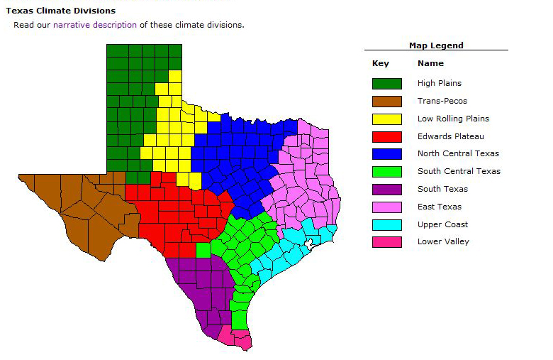
Texas Climate Divisions
Summary: Texas is divided into 10 climate divisions by the National Weather Service. These divisions are geographically referred to as the High Plains, Trans-Pecos, Low Rolling Plains, Edwards Plateau, North Central Texas, South Central Texas, South Texas, East Texas, Upper Coast, and the Lower Valley.
High Plains: The High Plains division is located in the most northern part of the state (the Texas panhandle region). The 39 counties included in this division are Andrews, Armstrong, Bailey, Briscoe, Carson, Castro, Cochran, Crosby, Dallam, Dawson, Deaf Smith, Floyd, Gaines, Glasscock, Gray, Hale, Hansford, Hartley, Hemphill, Hockley, Howard, Hutchinson, Lamb, Lipscomb, Lubbock, Lynn, Martin, Midland, Moore, Ochiltree, Oldham, Parmer, Potter, Randall, Roberts, Sherman, Swisher, Terry, and Yoakum.
Trans-Pecos:. The Trans-Pecos division is located in the most western tip with the state of New Mexico bordering on the north and the country of Mexico bordering on the south. The 14 counties included in this district are Brewster, Crane, Culberson, Ector, El Paso, Hudspeth, Jeff Davis, Loving, Pecos, Presidio, Reeves, Terrell, Ward, and Winkler
Low Rolling Plains: The Low Rolling Plains division is located east of the High Plains with Oklahoma bordering on the north and the Edwards Plateau bordering on the south. The 28 counties included in this division are Baylor, Borden, Childress, Coleman, Collingsworth, Cottle, Dickens, Donley, Fisher, Foard, Garza, Hall, Hardeman, Haskell, Jones, Kent, King, Knox, Mitchell, Motley, Nolan, Runnels, Scurry, Stonewall, Taylor, Wheeler, Wichita, and Wilbarger.
Edwards Plateau: The Edwards Plateau division is located south of the Low Rolling Plains. Areas surrounding (moving clockwise from the west) are Trans-Pecos division, High Plains division, Low Rolling Plains division, North Central Texas division, South Central Texas division, South Texas division, and the country of Mexico. The 28 counties included in this district are Bandera, Blanco, Burnet, Coke, Concho, Crockett, Edwards, Gillespie, Irion, Kendall, Kerr, Kimble, Kinney, Lampasas, Llano, McCulloch, Mason, Menard, Reagan, Real, San Saba, Schleicher, Sterling, Sutton, Tom Green, Upton, Uvalde, and Val Verde.
North Central Texas: The North Central Texas division is located in the most northern central part of Texas with the state of Oklahoma bordering on the north. Divisions surrounding North Central Texas (moving clockwise from the east) are East Texas, South Central Texas, Edwards Plateau and the Low Rolling Plains. Regions included in this division (but not outlined in this map) are Cross Timbers and the Blacklands. The 44 counties included in this division are Archer, Bell, Bosque, Brown, Callahan, Clay, Collin, Comanche, Cooke, Coryell, Dallas, Delta, Denton, Eastland, Ellis, Erath, Falls, Fannin, Grayson, Hamilton, Hill, Hood, Hunt, Jack, Johnson, Kaufman, Lamar, Limestone, McLennan, Milam, Mills, Montague, Navarro, Palo Pinto, Parker, Rockwall, Shackelford, Somervell, Stephens, Tarrant, Throckmorton, Williamson, Wise, and Young.
South Central Texas: The South Central Texas division is located just below North Central Texas. Areas surrounding (moving clockwise from the north) are North Central Texas division, East Texas division, Upper Coast division, the Gulf of Mexico, Lower Valley division, South Texas division, and the Edwards Plateau division. The 27 counties included in this division are Aransas, Austin, Bastrop, Bee, Bexar, Burleson, Caldwell, Colorado, Comal, De Witt, Fayette, Goliad, Gonzales, Guadalupe, Hays, Karnes, Kenedy, Kleberg, Lavaca, Lee, Medina, Nueces, Refugio, San Patricio, Travis, Washington, and Wilson.
South Texas: The South Texas division is located south of Edwards Plateau. Bordering on the east is the South Central division. Bordering on the south is the Lower Valley division. Bordering on the west is the country of Mexico. The 15 counties included in this district are Atascosa, Brooks, Dimmit, Duval, Frio, Jim Hogg, Jim Wells, La Salle, Live Oak, McMullen, Maverick, Starr, Webb, Zapata, and Zavala.
East Texas: The East Texas division is located the the most northeastern part of the state. Areas surrounding this division (moving clockwise from the north) are the state of Oklahoma, the state of Arkansas, the state of Louisiana, Upper Coast division, South Central division, and the North Central division. The 43 counties in this division are Anderson, Angelina, Bowie, Brazos, Camp, Cass, Cherokee, Franklin, Freestone, Gregg, Grimes, Hardin, Harrison, Henderson, Hopkins, Houston, Jasper, Leon, Madison, Marion, Montgomery, Morris, Nacogdoches, Newton, Panola, Polk, Rains, Red River, Robertson, Rusk, Sabine, San Augustine, San Jacinto, Shelby, Smith, Titus, Trinity, Tyler, Upshur, Van Zandt, Walker, Waller, and Wood.
Upper Coast: The Upper Coast division is located south of East Texas with the state of Louisiana bordering on the east and the Gulf of Mexico bordering on the south. The 13 counties included in this district are Brazoria, Calhoun, Chambers, Fort Bend, Galveston, Harris, Jackson, Jefferson, Liberty, Matagorda, Orange, Victoria, and Wharton.
Lower Valley: The Lower Valley division is located at the most southern tip of the state. The three counties included in this division are Cameron, Hidalgo, and Willacy.
http://www.nass.usda.gov/Statistics_by_State/Texas/Charts_&_Maps/cwmap1.htm


Recent Comments